YOUR STAY IN WEST FRIESLAND gives YOU, YOUR FAMILY AND/or FRIENDS AN IDEAL OPPORTUNITY TO see what this place has to offer.
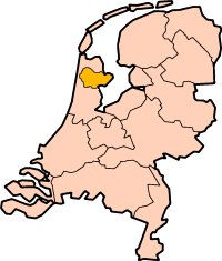
WEST FRIESLAND
West Friesland is a region in the north of the province of North Holland, enclosed by the West Omringdijk and located south of the Wieringermeer. Hoorn, Enkhuizen, Hoorn and Schagen are the most important places in the region. A part of the municipality of Alkmaar is within the West Omringdijk. The city center of Alkmaar is not part of West Friesland.
HISTORY
One of the oldest traces of habitation in the region is dated to the New Stone Age with the discovery of a skeleton (Cees de steentijdman).
In ancient times, the river divided the Flehi, which culminated in the Wadden Sea, Friesland into an eastern and western part. By coastal erosion of the Almere disappeared part of the shire Westflinge.
Historically, the significance of West Friesland (or similar expressions) shifted several times. In the Middle Ages the area between the Tideway and Vlie often referred to as Western Frisia or Frisia west of the Vlie. The first mention of West Friesland under this name, occidentalis Fresia, dates from 1101. However, this is a smaller geographic area as distinct from Holland, which this year is also mentioned for the first time.
From the 11th century the West Friesland was for three centuries the de facto autonomous glory, the Frisian Freedom, as the West Frisians did not want to submit to the counts of Holland. One speaks in this connection have a "peasants 'republic'. After Floris V West Friesland had conquered, followed uprisings that under Count John I by John III of Renesse in 1297 were suppressed with the battle of Vronen. Since that time, West Friesland is a part of the county of Holland. The name West-Friesland is then used for the two bailiwicks in the West Omringdijk, the meaning it has today, but they indicated there is also the whole Noorderkwartier outside Kennemerland join, as in the States of Holland and West Friesland.
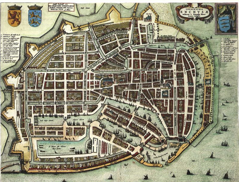
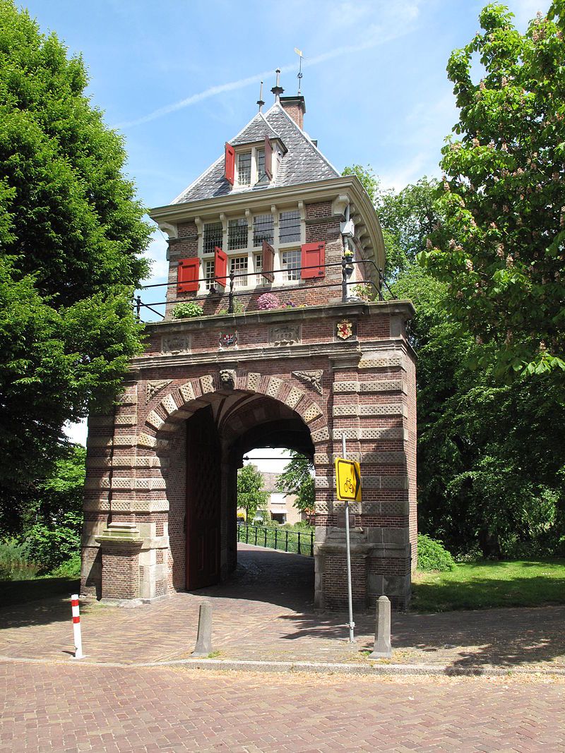
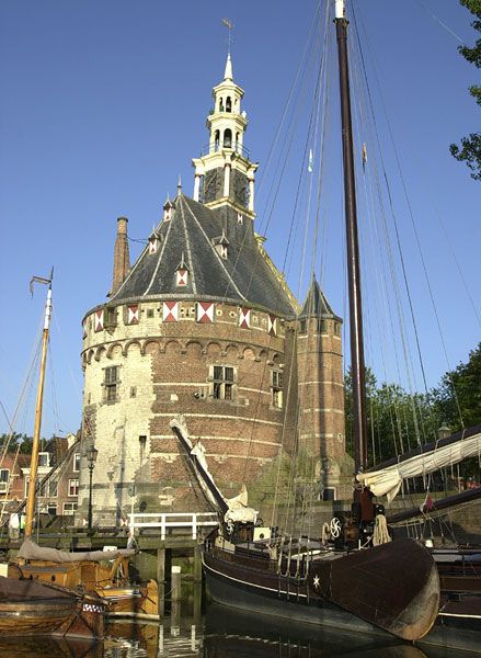
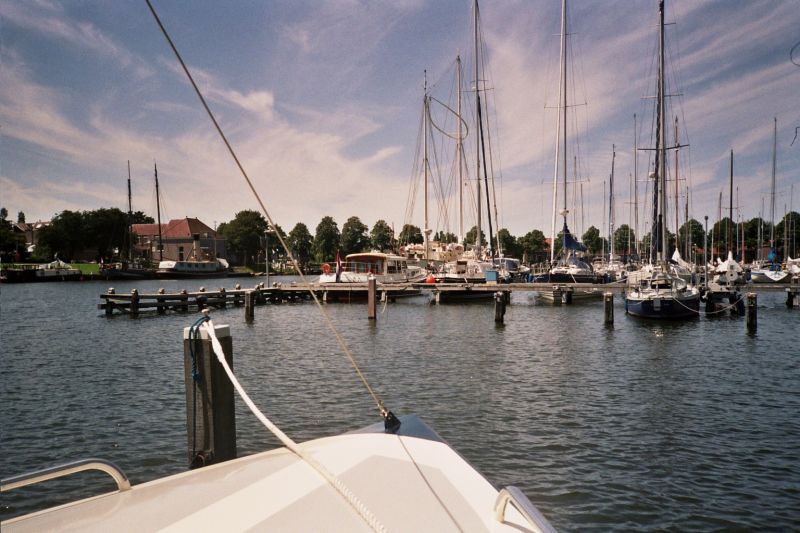
ENKHUIZEN
Enkhuizen is a city and municipality located on both the Markermeer and the IJsselmeer. The population is 18 383 inhabitants in an area of 116.04 km² (of which 103.62 km² water). Enkhuizen is known as the 'Herring City "because of its past as a center for the herring fishery. Partly due to the water sports, the city is an important touristic center. In addition, the town has internationally renowned seed companies and horticulture, as well as a cluster of plastics industry.
The town is intersected by canals and lies largely within the well-preserved 16th-century rampart.
Sights
● Marinas
● Zuiderzee Museum (outside and inside)
● The urban projects Heritage Area and Snouck van Loosenpark
● Swimmingpool Enkhuizerzand
● Sprookjeswonderland Ferrytalewonderland (for the little ones)
● The colorful flower and seed fields around the city.
● Charterboats
● Rampart
● Beach on the IJsselmeer
Monuments
● Boerenboom (1593)
● Buyskeshuis (1732)
● Café van Bleiswijk
● Drommedaris (1540) (spits 1648)
● Koepoort (1730)
● Oude Gouwsboom (1593)
● Peperhuis (1567)
● Snouck van Loosenhuis (1786)
● Snouck van Loosenpark (1897)
● Spuihuisje (17e eeuw)
● Stadhuis (1688)
● Stadsgevangenis (1612)
● Staverse Poortje (1615)
● Treinstation (1885)
● De Vriesstichting
● Waaggebouw (1559)
● Weeshuis (gevel 1616)
● Wester - of Sint Gommaruskerk (1470-1516)
● De Westfriese Munt (1611)
● Sint Franciscus Xaveriuskerk (1906)
● Zeemuur (1608)
● Zuider- of Sint Pancraskerk (1524)

HOORN
Hoorn is settled via the Hoornse Hop to the Markermeer. population is 71 888 people. The municipality of Hoorn is 52.49 km², of which 32.62 km² water.
About the origin of the name Hoorn - Hoorn in old spelling also (e) or Hoirne - make many myths circulating. The name, according to an old Friesian legends derived from the stepson of King Radboud, named Hornus. Other stories for the name come from a sign with a horn that hung early 14th century to one of the establishments on the Red Stone. A third variant proposes that Hoorn is derived from the horn shape of the first ports. The name Hornicwed may well be the original story. The medieval Hornic means corner, and wed or wedor is the medieval word for water. Hornicwed would mean the location in a corner of the coastline.
Sights
● Marinas
● Waag
● Westfries Museum
● Museumsteamtram Hoorn-Medemblik
● Museum of the twentieth century
● Bossuhuizen
Monuments
● The Main Tower
● Hoorn, St. Anthony Church or Oosterkerk
● Cultural Manifesto
● Statenlogement (1613) / Cecilia Chapel (1453)
● Boterhal or St John's Hospital (1563)
● Room Hoorn East India Company, VOC Warehouse (1606/1610)
● Westfriesmuseum or Staten (façade 1631)
● Parish House
● Warehouses (inter alia cheese) Bierkade and Appelhaven
● Main Tower (1532)
● Room Ho0rn West India Company (1629, façade 1784)
● Timmermans Guildhall
● Monastary Gate / Old Vrouwenhof (1606)
● Post Office (1878)
● Foreestenhouse (1724)
● St. Pietershof (1692)
● Orphanage, a garden, and Mary Chapel (1508)
● Claes Stack's Court (1682)
● The Goals (early 17th century)
● Maria or Powder Tower (1508)
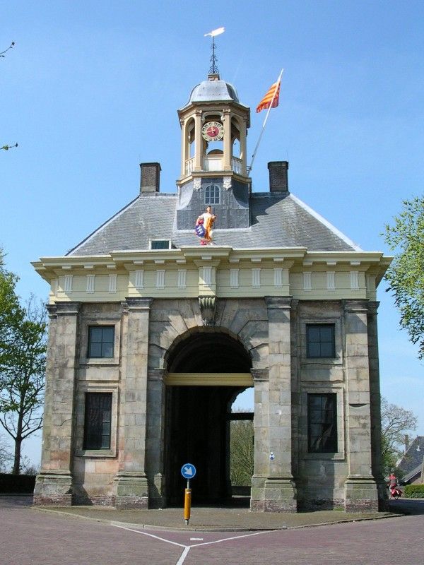
● Easter Gate (1576)
● Drechterlandsehuis (1728)
● Admiralty Buildings Easter Island (the Krententuin)
● The Crowned Hunt Hulk (1878)
● Mission House Mill Hill (1929)
● Statue of J.Pz.Coen (1893)
● Boys of the Bontekoe
● Trainstation (1884)
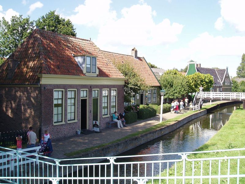
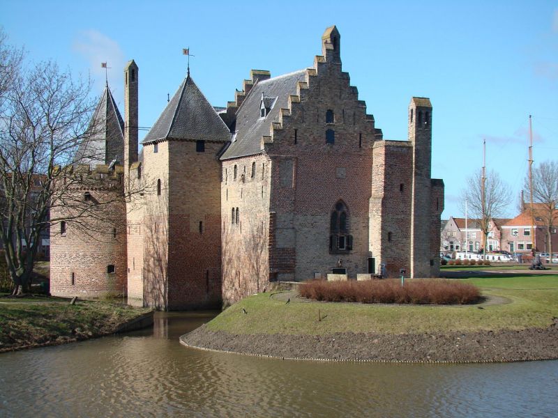
MEDEMBLIK
Medemblik is the oldest town in West Friesland and has a population of 8492.
The name "Medemblik" may have come from the watercourse or Medemelake Medemelacha (watercourse in swampy terrain) that once run through this place. In 1289 Medemblik became the first place in West Friesland that was grated city rights by Count Floris V. At the end of the 13th century Floris V had to build a citadel, now known as Radboud Castle. The town was besieged in 1517 by the army of Johan van Selbach, supported by the hijackers of Grand Pier and Wijerd Jelckama. A great fire struck the town in 1555. At the beginning of the Eighty Years' War, in 1572 and 1588, the city was besieged by Beggars and Princely troops.
Medemblik has many historic facades, and a town hall (1939) build by architect AJ Kropholler. There is also a working flour mill (Mill Shepherd, rebuilt 1986-1990).
Sights
● Monastary house next to St. Martin
● Several buildings on the Western Basin, including the "Dijkhuis"
● The warehouse "De Wolff" from 1667 to the First Island
● Historical building "court Medemblick"
● The three warehouses called "Hope" to the First Island
● The "Crooked House" in the Pre Island
● The only house in Medemblik in the Louis XVI style from 1728
● Synagogue Medemblik, Medemblik where the Jews were deported from during World War II
● War Memorial for killed Medemblik soldiers, Jews and resistance fighters.
● Easter Harbour 21 historic house from the 18th century
● The canal the "Mother Angels" at the Achterom
● The warehouse of the West India Company at the Easter Harbour
● The Reformed Orphanage "The Four Orphans" with gate dated 1765 into Torenstraat; the statues of the orphans above the gate once graced a Dutch postage stamp;
● De Waag on the cheese market
● The "Kogge House" dated 1613 on Rue Neuve
● The (since 2011 rebuilt) City Hall with remains of the old town hall in the Dam; dated 1941, the Hall was a bit further to the Rue Neuve;
● Train Station Medemblik and part of the track Hoorn-Medemblik
● "The Supreme", opposite flour mill "The Shepherd", wooden house management Zuiderzeewerken
● The "Swarte Woifke", built in 1640 and rebuilt in 1740 and 1780, the Easter Harbour
● The "Witte Huys," At the first island, junction High Lane, now clothing store

Monuments
● The 16th-century canal "It Havent"
● The City Farms
● The "Dijkhuis" (1599)
"Country Yard", built 1799-1800, turret 1808, once shelter for the Navy and then Provincial Hospital (for the insane), since 1966 and abandoned in the 80's organized as apartment building, surrounded by a park;
● The mill "The Shepherd" (destroyed in 1948, rebuilt in 1986-90 with many new materials but also old parts from 1695 from a mill romp "The Shepherd" from Jisp later Willeskop were used, which is why the name is held and this mill monument)
● The "Radboud Castle" (1286-1288), restored after dilapidation in 1888
● The Dutch Steamengine museum 1869 (also Stoomgemaal Four North Koggen)
● The "Murray House" overlooking the tomb of Lord George Murray
● Widow houses (1500)
● The "Tax-Huys' at Torenstraat and the Western Basin
● The "Quotes-Huys" on the left side of the Tax-Huys
● Property at the Bagijnhof Renaissance
● The "Water House" with little loud bell in the turret, the Western Basin.
● The "Regthuys", identified by a lantern just above the door, located at the Western Basin
● The "Pink House", birthplace of the architect of the original mills at the "Four North Koggen" polder built, is now on that spot steam engine pump
● The Bakery Museum "The Old Bakery"
● The Main Post Office, the Van Houwing Park in the downtown area, now no longer in use
● Remains of the East Gate to Castle Radboud
Maak jouw eigen website met JouwWeb